Press Release 2026.08.28
Synspective Signs Agreement on the Use of Satellite Imagery During Disasters with NTT DOCOMO and NTT DATA
Synspective Inc. today announced that it has signed an “Agreement on the Use of Satellite Imagery During Disasters” with NTT DOCOMO, Inc. (“DOCOMO”) and NTT DATA Japan. Under the agreement, the three companies will work together to support faster, broader assessment of disaster-affected areas and the restoration of communication infrastructure.
Under this agreement, satellite imagery, which enables broad, area-wide assessment, will be used to evaluate conditions such as flooding, landslides, and road passability from above, even when on-site access is difficult due to road closures, power outages, or severe weather. By complementarily using optical satellite imagery, which provides intuitive visual clarity, and SAR satellite imagery, which can observe the ground at night or through bad weather, the initiative aims to enable rapid assessment of disaster conditions, identify recovery routes, and achieve the early restoration of communication services.
Background
When a major earthquake, storm, or flood occurs, and communication service disruptions arise due to power outages or transmission line failures, restoring services quickly requires understanding both the damage to communication facilities and the condition of the roads needed for recovery access. However, in areas affected by road closures or flooding, on-site access can be difficult, and getting a full picture of the damage can take time. To address these challenges and ensure the early restoration of communication services even during large-scale disasters, it is crucial to use methods that provide broad-area damage assessments and evaluate site accessibility, in addition to gathering information on the ground.
DOCOMO works to restore communication services after disasters, including assessing equipment damage and carrying out emergency repairs. NTT DATA has spent over 20 years developing and providing solutions that leverage Earth observation satellite data. Synspective uses SAR satellites it operates itself to provide imagery and analysis during disasters. By combining the capabilities of each company, the three parties have signed this agreement to apply satellite imagery to the restoration of communications infrastructure during disasters and to verify its effectiveness and operational methods through real-world disaster response.
Key Areas of Collaboration
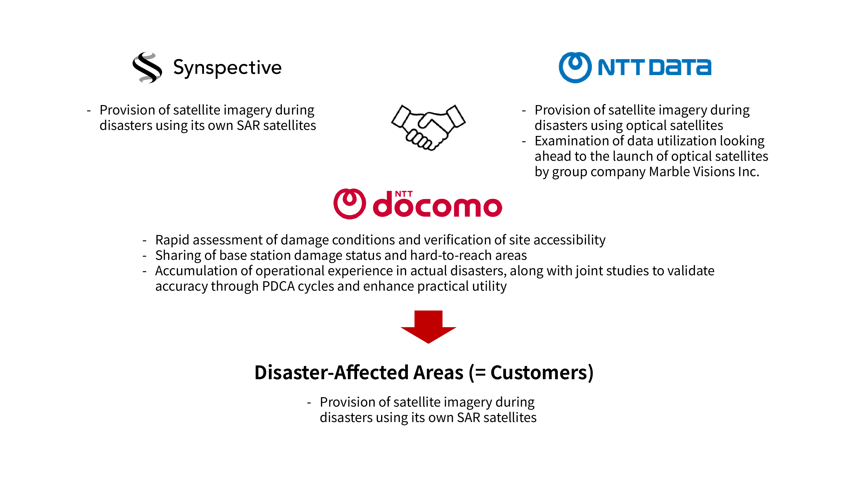
NTT DATA will provide optical satellite imagery (1), which offers high visual clarity, while Synspective will provide SAR satellite imagery (2), which can be captured even at night or in poor weather. DOCOMO will cross-reference this imagery with data on base station damage and information released by public agencies, enabling faster and more accurate assessment of disaster conditions and supporting the early restoration of communication services.
The parties will establish lines of contact for both normal operations and disaster situations, holding liaison meetings and sharing the latest developments to ensure the smooth use of satellite imagery when disasters occur. The parties will also conduct joint studies to enhance the practical utility of satellite data by accumulating operational experience in actual disasters and validating accuracy through a continuous PDCA cycle.
Roles of Each Company
DOCOMO has adopted improving system reliability, securing critical communications, and the early restoration of communication services as the basic pillars of its disaster response policy, and works to provide services that are resilient to disasters. When a disaster strikes, DOCOMO assesses damage to communication facilities, such as base stations, and the condition of roads needed for recovery access, and carries out emergency restoration using mobile base station vehicles and mobile power supply vehicles.
NTT DATA has spent over 20 years developing and providing solutions that use Earth observation satellite data, working to advance disaster response through digital technology in disaster prevention and resilience. Through AW3D (3) , a global digital 3D mapping service using satellite imagery, and by using satellites and drones to safely and quickly assess the full scope of damage, NTT DATA aims to support decision-making at disaster response headquarters and related organizations. The company has also worked to develop and commercialize technology for assessing flood damage to residential buildings using satellite and drone imagery. Under this agreement, NTT DATA will examine ways to enhance disaster response by leveraging optical satellite imagery. Looking ahead to expanded imaging opportunities from the planned optical satellite launches by its group company, Marble Visions Inc., NTT DATA aims to enable faster and more continuous assessment of disaster conditions when emergencies strike. Because optical satellite imagery closely resembles what is seen by the human eye, it allows for intuitive, visual understanding of damage. This supports rapid decision-making and recovery efforts by helping confirm the extent of damage and evaluate road passability.
Synspective is a solutions provider that handles everything from the development and operation of its StriX series of small SAR satellites to the sale of SAR data and analytical solutions. Because SAR satellites use radio waves to observe the Earth's surface, they can capture ground conditions even at night or in poor weather. Drawing on the responsiveness of its own satellites, Synspective has provided satellite imagery and analytical data during natural disasters such as earthquakes, floods, and landslides, supporting damage assessment and rapid decision-making.
Looking Ahead
By leveraging the complementary strengths of optical and SAR satellite imagery, Synspective will advance joint studies to enhance the practical utility of satellite data by accumulating disaster-response track records and conducting PDCA-driven accuracy validation. Moving forward, combining satellite data with AI image analysis technology will go beyond identifying damage and recovery routes to help prioritize response efforts and enhance decision-making. Expanding this to risk analysis and disaster scenario planning, the companies aim to strengthen end-to-end disaster response capabilities, both before and after a disaster strikes.
Notes
(1) Optical satellite imagery: Images obtained by optical sensors mounted on satellites that observe sunlight and other light reflected from the Earth's surface. Because these images closely resemble what the human eye sees, they are easy to interpret visually and are used to confirm disaster conditions.
(2) SAR satellite imagery: Images obtained by satellites equipped with SAR (synthetic aperture radar), which emit microwaves toward the Earth's surface and capture the reflected waves. These images can be captured at night and are less affected by clouds or rain, making them useful for assessing disaster conditions.
(3) AW3D® Global Digital 3D Map | NTT DATA: https://www.nttdata.com/jp/ja/lineup/aw3d/
*"AW3D" is a registered trademark of NTT DATA Corporation and the Remote Sensing Technology Center of Japan.
*Other product names, company names, and organization names are trademarks or registered trademarks of their respective companies.