Use Case 2026.10.21
Monitoring Highways and Bridges in Brazil
Only about 38 percent of Brazil’s surveyed highways are in good or optimal condition, according to the 2025 national road survey by the Confederação Nacional do Transporte (CNT), which covered more than 114,000 kilometers. The survey also counted more than 2,100 critical points, the places where the risk of accidents or serious infrastructure problems is highest. Bridges tell the story most clearly. In June 2026, a recently opened bridge over the Iaco River in Sena Madureira, Acre, collapsed and injured four people. Eighteen months earlier, the Juscelino Kubitschek de Oliveira Bridge between Maranhão and Tocantins, built in the 1960s, gave way and sent cars and trucks into the Tocantins River, killing at least nine people.
The Brazilian government runs much of the network. In 2025, private concessions operated about 15,800 kilometers of federal highway across 31 contracts, and the National Department of Transport Infrastructure (DNIT) runs most of the rest. Concessionaires manage the highway and the right-of-way corridor along it, and Colombia follows a similar model with its transport agency. Routine inspection focuses largely on the road surface. However, what happens beneath and beside the road is much harder to see.
Interferometric synthetic aperture radar (InSAR) measures ground movement from space to the millimeter, and Synspective delivers this analysis today. A radar satellite records its distance to the same patch of ground on each pass, and comparing those measurements over time shows whether a road, a bridge foundation, or the slope beside it is sinking or rising, and how fast. A single analysis can cover thousands of kilometers of highway and thousands of bridges, far more than any team could survey in person. Every large structure has its own safety threshold, and InSAR shows how quickly the ground is moving toward it.
The right sensor depends on the site. X-band radar performs best on concrete and asphalt, where it captures fine detail. L-band penetrates vegetation to the ground beneath, which matters in hilly, forested terrain like much of Brazil and Colombia. Resolution matters as much as band. A higher-resolution analysis places far more measurement points along the same stretch of road, enough to pick out small changes in a single lane or bridge approach. Monitoring can then run in layers, with routine coverage across a network and closer attention wherever movement appears.
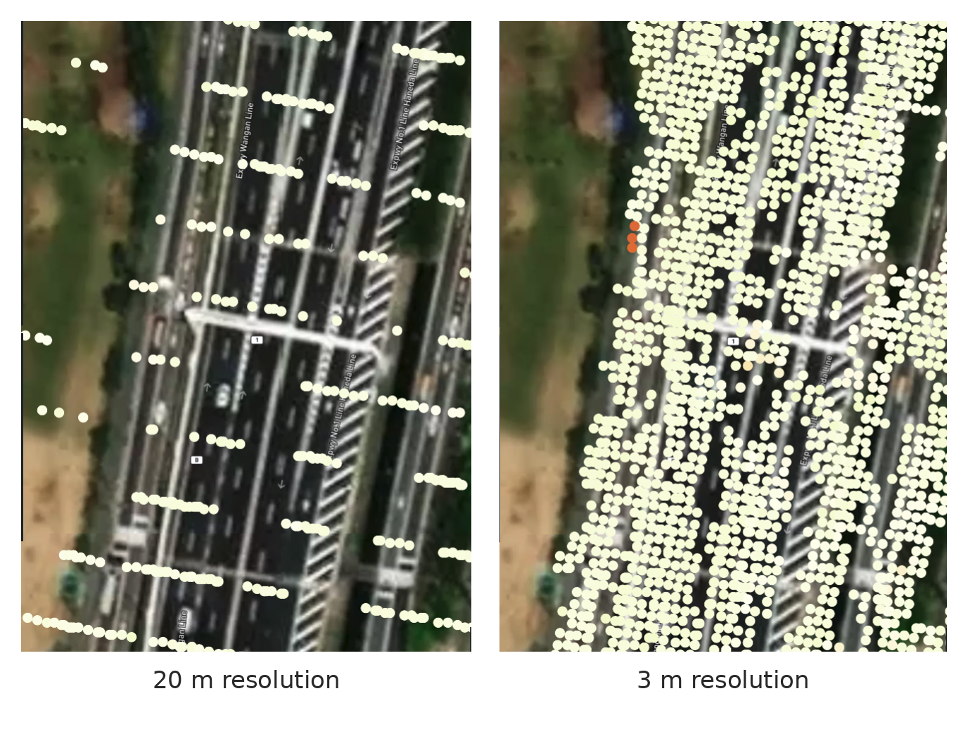
Image 1: Measurement points over a multi-lane expressway at 20-meter resolution (left) and 3-meter resolution (right). Higher resolution places far more points on the road.
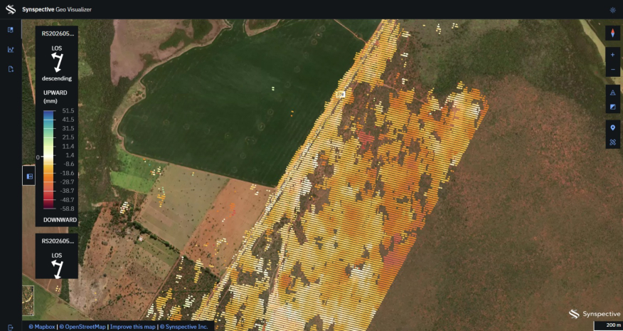
Working with DNIT, we analyzed a stretch of federal highway near Formosa, Goiás, from January 2025 to April 2026. The analysis covered about 107 square kilometers and placed more than 900,000 measurement points across the corridor. It traced a subsidence trend along the road infrastructure, the kind of steady change that can become a sinkhole or a failed section if left unchecked.
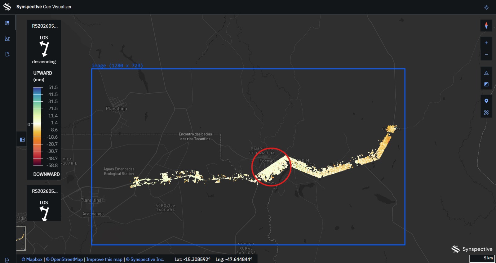
Image 2: InSAR analysis of a federal highway corridor near Formosa, Goiás, from January 2025 to April 2026. Orange and red show downward ground movement.
The road is only part of the picture. On another stretch of highway, the pavement shows almost no movement, while ground beside it has sunk by around 5 centimeters. In terrain like this, a highway often fails because something next to it gives way and drags the road down with it. Concessionaires are responsible for that corridor, and monitoring it lets them act before the movement reaches the asset.
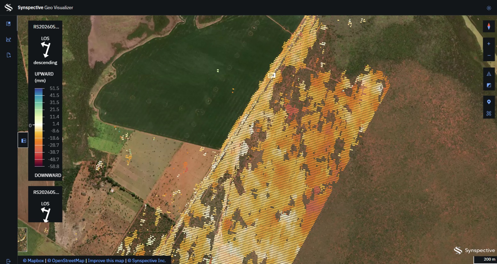
Image 3: A stretch of highway in Brazil. The road holds steady while ground beside it sinks by around 5 centimeters.
The bridge in Sena Madureira shows what this can look like before a failure. We analyzed a year of archive radar data over the structure ourselves, independent of any client. Measurement points on either bank moved in opposite directions from mid-2025 onward. One end sank by about 2 centimeters while the other rose by about 1.5, pulling apart by roughly 3.5 centimeters over the year. Divergence like that stresses a structure. The data cannot tell us when anyone should have acted, since every structure has its own threshold and those are rarely public. It does show that the movement was measurable months before the bridge came down.
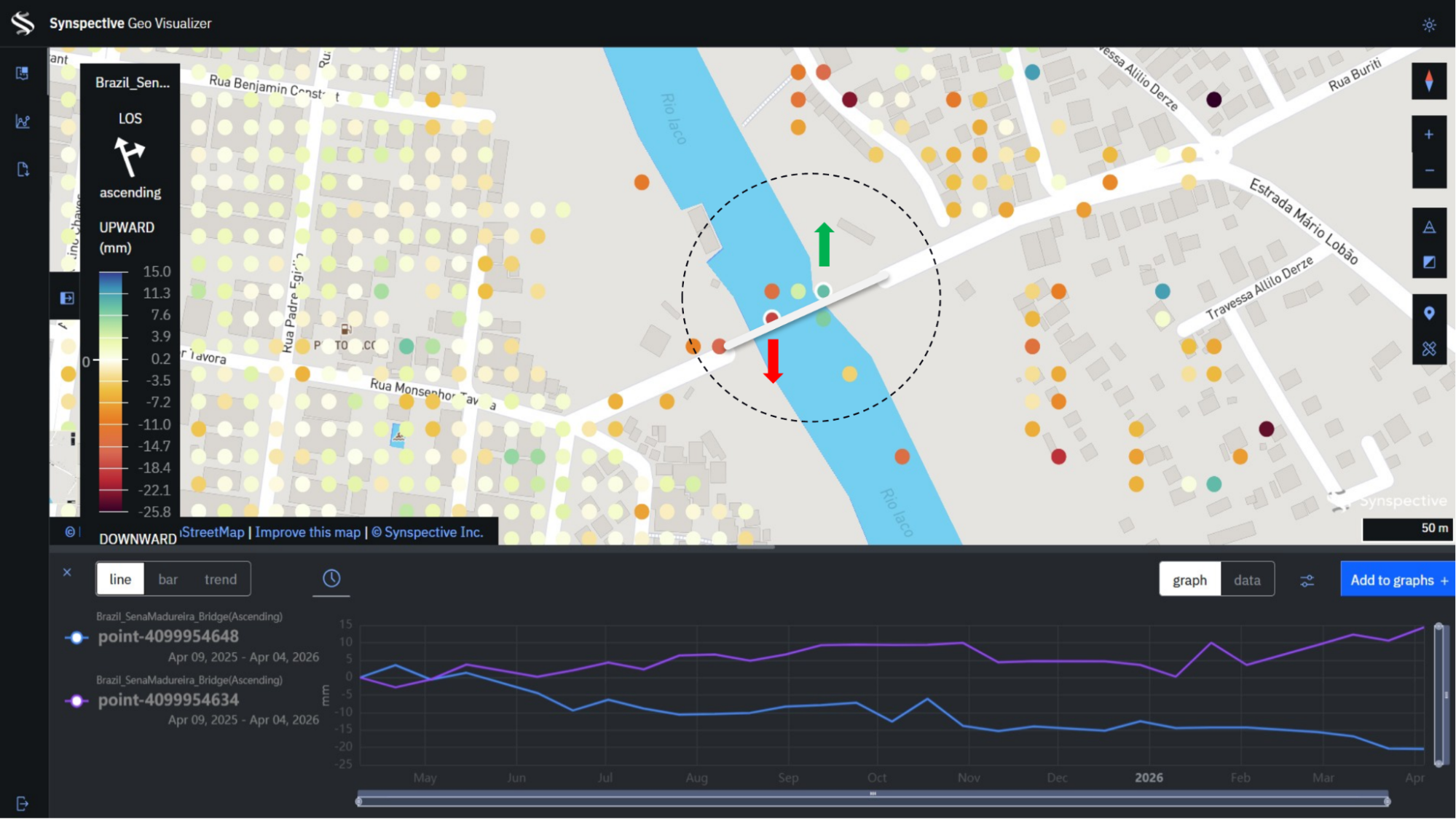
Image 4: Measurement points on either bank of the Iaco River in Sena Madureira, Acre, from April 2025 to April 2026. One end of the bridge sank while the other rose.
InSAR works best as one part of a wider monitoring system. Instruments in the ground and field inspections each play a role, and satellite measurement adds a view no ground team could match across a network the size of Brazil’s. A highway or bridge can cost millions or billions of dollars to build, and an early warning that heads off tens of millions in repairs pays for itself. In Japan, this is already routine. National guidelines set subsidence thresholds for roads, and operators act once a road crosses one.
Demand in the region is rising quickly. Highway concessions in Brazil already use InSAR, and there are frequent requests for proposals for highway and infrastructure monitoring. Today, our InSAR analysis draws on data from several radar missions. We are also working to integrate our StriX constellation, which will bring higher-resolution, higher-revisit monitoring to areas where movement is approaching a threshold.
Mining adopted this kind of monitoring after a series of deadly dam failures in Brazil. Highway operators don't need a disaster to reach the same point, since the time, money, and repair savings make the case on their own.
Project Contributors
Tata Lacale Canal leads Synspective’s business in Latin America from Rio de Janeiro and brings more than two decades of experience in commercial Earth observation and SAR data services across the region.
Andre Gavlak drives Synspective’s business expansion in Latin America as a Sales Engineer for Synspective USA. He brings over 20 years of experience to the geospatial and remote sensing sectors, and holds a doctorate in physical geography and a master’s degree in Remote Sensing & GIS.
References
Poder360, “Qualidade das rodovias melhora em 2025, mas 62% seguem problemáticas,” December 17, 2025.
Agência Nacional de Transportes Terrestres (ANTT), “Relatório de Gestão 2025,” April 2026.
SBT News, “Ponte nova de R$ 36 milhões desaba no interior do Acre,” June 6, 2026.
The Associated Press, “At least 9 people died when a bridge collapsed in Brazil,” NPR, December 27, 2024.