Blogs 2026.09.28
Narita's Highway Junction and Farmland in Spotlight Enhanced
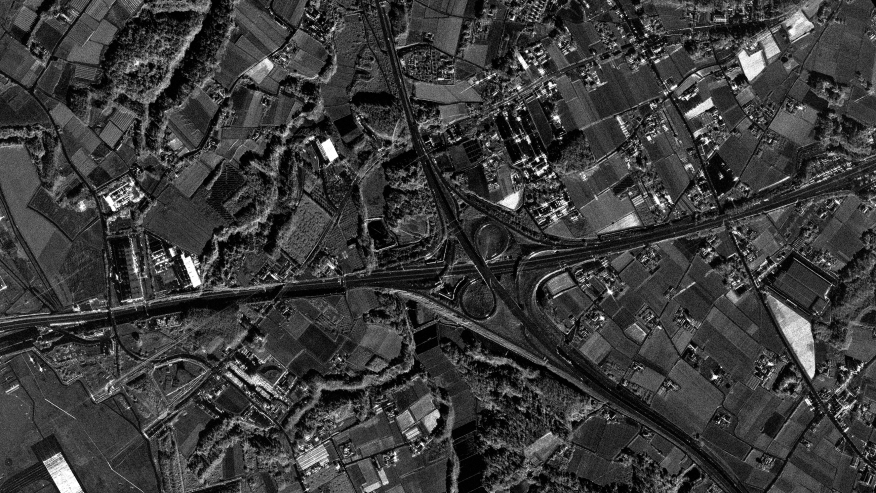
This scene captures the highway junction east of Narita, Chiba, where an expressway interchange cuts through one of the Kanto region's most productive farming areas. It was acquired by Synspective's StriX satellite in Spotlight Enhanced mode. Because SAR uses radar rather than sunlight, it sees through clouds and works day and night, making it a reliable way to monitor road infrastructure and the land around it in any weather.
These are the points that are specifically interesting in this image:
A Convergence of Infrastructure and Farmland
- The Rural Intersection: Pinpointing the coordinates (Lat: 35.8152°, Lng: 140.3877°), a prominent road intersection anchors this image. Because paved asphalt is smooth, it acts like a mirror to the satellite's radar, bouncing the signal away to create stark, dark lines. Against this dark pavement, the metallic infrastructure of the intersection, such as guardrails, traffic lights, and vehicles, acts as a reflector, appearing as exceptionally bright, distinct points.
- Geometric Farmland Patchwork: The surrounding agricultural land reveals a highly detailed patchwork of textures. SAR radar interacts uniquely with different ground surface conditions. Fields with dense, mature crops scatter the radar signal and appear brighter and highly textured, while flooded plots reflect the signal away, appearing much darker.
- Spotlight Enhanced Clarity: Because the image has far less grain than a standard SAR image, the edges of the expressway, its ramps and the drainage channels along the fields appear as clean, crisp lines, and you can still tell one field from the next by its texture. In a standard image, this kind of fine detail tends to get buried in the noise.
- Highly detailed images: Because of the aforementioned observation technique, you can clearly observe detailed structures, like poles and guardrails along the highway and the lids of the fuel tanks of Narita Airport.
About the observation:
This image is taken in Spotlight Enhanced mode.
The Spotlight Enhanced mode applies a 3-look processing in the azimuth direction to effectively suppress the speckle noise characteristic of SAR imagery.
In our Spotlight Enhanced mode, the antenna beam is steered with optimized precision while leveraging advanced signal processing techniques. This allows for an even more refined analysis of ground surface textures and micro-infrastructure, making it ideal for detailed agricultural monitoring and structural assessments.
Full image:

Download this Data set from our Data Gallery to see more details of this area directly to data set